Flood hydrology, reimagined.

Hydrometric is an open hydrological analysis platform that brings together FEH analysis, climate change assessment, reporting and collaborative review in a single workspace.

Built on established methods and transparent calculations, Hydrometric helps practitioners make better decisions while creating opportunities for shared learning across the hydrology community.

Shared learning only works if the underlying analysis is trusted. That’s why Hydrometric is grounded in established hydrological practice, with visible calculations and decisions that can be reviewed.

The FEH statistical method is implemented with transparent QMED estimates and donor adjustment. Pooling groups, growth curves and climate change allowances are computed in seconds and presented through a transparent decision tree, combining the rigour practitioners expect with the transparency, collaboration and shared learning modern hydrology demands.

Better decisions through shared learning

Hydrological analyses are often undertaken in isolation with valuable knowledge remaining hidden within individual projects.

Hydrometric was created around a different idea: that the profession benefits when we can learn from each other.

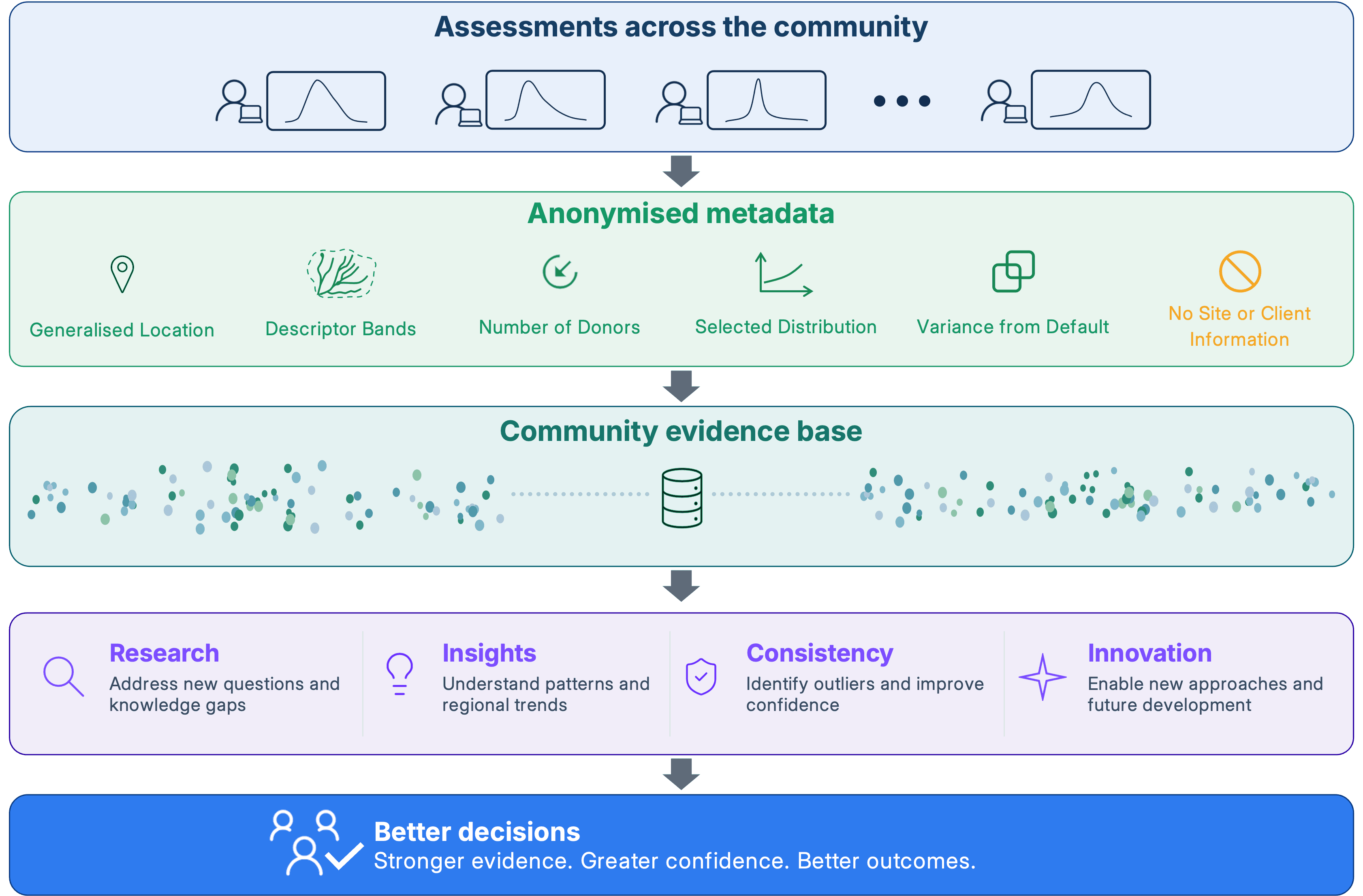
With your consent, each assessment can contribute a summary that helps build a stronger evidence base for hydrology. Project data remains private, but the patterns emerging across many assessments can be returned to the profession as practical insight.

  • A clearer picture of hydrological behaviour across catchments, methods and decisions
  • Better understanding of uncertainty and professional judgement in practice
  • Insights that benefit the wider community, not Hydrometric alone

No individual organisation could build that evidence base on its own. Together, the hydrology community can.

Hydrometric community evidence approach: assessments contribute anonymised metadata to a shared evidence base, supporting research, insights, consistency and innovation.

As Hydrometric grows, the community benefits from:

  • Improved understanding of regional trends
  • Better visibility of donor catchment performance
  • Outlier and consistency checks
  • Evidence to support future gauging investment
  • New opportunities for research and innovation
  • Greater confidence in method choices

Your project data remains private. Only summaries you choose to share contribute to community learning. Learn more about the data we collect.

Everything you need, nothing you don't

Hydrometric brings together the FEH statistical method, climate change allowances, mapping, reporting and collaborative review tools in a single platform.

One platform. One workflow.

No copy-pasting between spreadsheets and reports. No black boxes. Work from catchment descriptor edits through to your Flood Estimation Report, with collaborative review and recorded sign-off in the same workspace.

FEH Statistical Analysis

Built on SM2025 equations, with visible descriptors, donor adjustment, pooling and recorded calculation provenance.

Climate Change Allowances

Peak river flow climate change allowances follow the published national guidance for England (Environment Agency, UKCP18), Wales (Welsh Government and Natural Resources Wales) and Scotland (SEPA).

Mapping and GIS

NRFA Peak Flow Dataset station maps, catchment boundaries, LiDAR overlays and spatial search.

Decision Trees

See every pathway explored, every alternative considered. Select your preferred method - every parameter choice and override is recorded.

Review and Collaboration

Invite reviewers into a project, record review verdicts and sign-off, and let reviewers explore alternatives in their own sandbox forks without touching the original.

Automated Reporting

FEH technical notes generated from your analysis. Graphs, tables, methodology - no more copy-paste.

Transparent Calculations

Calculation steps are visible and auditable, with recorded inputs, method choices and provenance to support review.

AI / MCP Integration

Rule-based hints flag discordant pooling stations, heterogeneity and outliers. Compatible MCP clients can access supported assessment and calculation outputs through the remote MCP server.

Whether you're...

  • Delivering flood studies
  • Undertaking mapping studies
  • Reviewing technical work
  • Managing flood risk
  • Carrying out research
  • Studying hydrology

Hydrometric provides a transparent, collaborative environment for hydrological analysis.

Open calculations. No black boxes.

See every pathway explored, every decision considered and every assumption applied.

Calculation steps are visible and auditable within the platform. Statistical methods have been tested on reference cases against WINFAP and UKFE; the scope and results of those checks are recorded separately.

This transparency helps you understand, review and verify your analysis, not simply accept a result.

Built for collaboration

Review together. Learn together.

Hydrological estimation is rarely a solo exercise. Hydrometric allows teams to work from a shared record, invite reviewers directly into projects, revisit previous studies and build consistency across an organisation.

Whether you’re an individual consultant, a small practice or a national team, Hydrometric is designed to make review and knowledge sharing part of the normal workflow rather than an administrative burden.

>_ Agent-native

Hydrology, agent ready

Compatible MCP clients can run supported gauged and ungauged assessments and access QMED, growth curves, design flows and reports, with recorded method and data provenance. The hydrologist stays in control: agents can start with the default route, with results available for review.

Method Space via API lets you compare your own estimates - including results from another tool - with the Hydrometric default and the range of supported method choices. See pricing for availability and per-run charges.

  • Remote MCP server at /api/mcp - Streamable HTTP, with no local server installation required.
  • Per-user API keys, created from your account and revocable at any time.
  • Supported default-route outputs include QMED, growth curves, design flows and reports. See the developer docs for tool coverage and requirements.

Created by hydrologists for hydrologists

Hydrometric was founded by Chris Cameron-Hann and Clare Winter, who together bring more than 40 years of experience in hydrology, water resources and flood forecasting.

They created Hydrometric because they wanted better tools, greater transparency and a stronger community approach to hydrological analysis.

Meet the team and learn our story
Chris Cameron-Hann
Clare Winter
Clare Winter

Ready to modernise your flood risk workflow?

Hydrometric works best when the community helps shape it.

Every assessment makes the next one better.

UK Flood Hydrology Roadmap

  • UK Flood Hydrology Roadmap Outcome 3: Latest Science into Practice
  • UK Flood Hydrology Roadmap Outcome 4: Relationships and Community
  • UK Flood Hydrology Roadmap Outcome 6: Scientific and Operational Skills
  • UK Flood Hydrology Roadmap Outcome 7: Open Source and Access
  • UK Flood Hydrology Roadmap Outcome 10: Next Generation Hydrology models